|
Preferred
orientations of the buried valleys
From the beginning of the mapping project it has been clear that the bured valleys had different preferred orientations in different parts of the country. Typically two or more preferred orientations were seen within specific localities. Neighboring localities could show the same tendencies, but often large differences were seen.
The patterns in the preferred orientations of the valleys points towards a formation history with a complex interplay of different factors. The character of the outcome has been dictated by where - geographically speaking - the valley was formed and at which point in time.
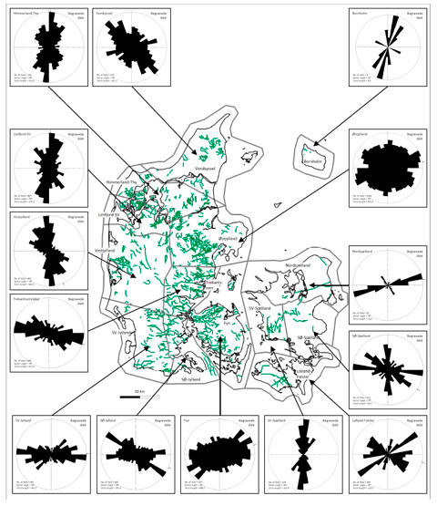
The analysis of the orientations of the buried valleys is made on the mapped center lines of the valleys. Denmark has been subdivided into 14 areas and in 10-degree intervals rose petals summarise the length of valleys within the intervals (see Figure to the right).
In the main part of the sub-areas there are 1-2 preferred orientations and in a few sub-areas 3 or maybe more preferred orientations. The differences between the sub-areas can be very large with up to 90 degrees difference between the dominant orientations. The analyses clearly shows that the differences are not based on coincidence and certain factors has a great influence on the resultant preferred orientations. The analyses of the orientations point to a complicated interaction between the glacier dynamics, the topography of the substratum, the lithology of the substratum and the tectonic framework of the region.
For further details we refer to the published papers listed on the Download page. As a supplement to the analyses of the buried valley orientations we have also performed analyses of the topographic valleys in the present day landscape and mapped faults in the subsurface.
|