|
Mapping procedures
Data
Numerous geophysical investigations in Denmark constitute the basis for the delineation of the buried
valleys. The geophysical methods comprise primarily
Transient ElectroMagnetic (TEM) and reflection seismic surveys,
and the geophysical data have been combined with lithological
data from the national borehole database Jupiter. The geophysical data is retrieved from the national geophysical database GERDA.
The buried valley mapping
A buried valley is defined as an oblonged depression which has been partially or completely filled with younger sediments.
The buried valleys are divided into two categories:
1) Partly buried or "open" valleys
2) Completely buried valleys
A buried valley can therefore at one extreme be a young valley with only a thin layer of young sediment at the bottom or at the other extreme be a very old, deep-seated and completely buried valley (figure to the right). The width of the valley is delineated at the top of the valley flanks as it can be interpreted from the data.
All
collected and relevant geophysical and lithological data from
the Danish onshore area is evaluated and examined
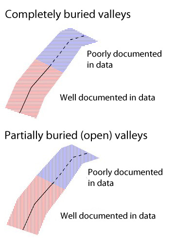
in order to map and describe the buried valleys. The interpreted buried valleys are mapped in MapInfo (GIS) using the signatures shown on the figure at the bottom right. Every mapped buried valley is designated a center line either as a solid line (well documented valley) or a hatched line (poorly documented valley). In addition to this, a polygon with different fill colour and hatching shows the valley width, lateral extent, degree of burial and degree of documentation (see figure, bottom right).
An important focus of the project has been to obtain a high degree of certainty and
objectivity in the process of valley mapping. The most important
criterion is that the lateral extent and the orientation of the
valleys must be unambiguously expressed in the data. Therefore,
no interpolations outside and between the surveyed areas are made, and the
map of the buried valleys should therefore be considered as representing the
minimum occurrence of buried valleys.
|
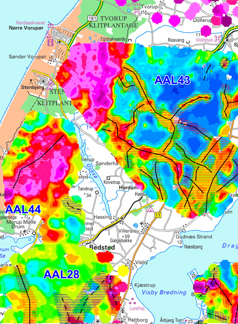
Resistivity map based on SkyTEM/TEM data with interpreted buried valleys drawn on top using the signatures shown below
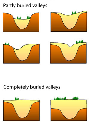
Partly and completely buried valleys
Signatures used in the mapping
|